Sam Gordon reports from Nicaragua on the territorial dispute between Nicaragua and Colombia over the San Andrés Archipelago, Caribbean St Andrews. He outlines the background in colonialism, the impact on the ethnic group living there and the small matter of rich oil and fishing resources.
The International Court of Justice (ICJ) at The Hague, in the Netherlands, is often swept by icy gales from the North Sea. But sometimes at least, the daily work of the jurists there gets to focus on sunnier climes, such as the Caribbean islands known as the San Andrés Archipelago.
That was the case in November of last year when the ICJ ruled that this group of islands and cays (low islands and sandy banks) were part of the national territory of the Republic of Colombia. The case was brought to The Hague by Nicaragua and contested by Colombia. As the court had already ruled that the three principle islands of San Andrés (St Andrew), Providencia (Providence) and Santa Catalina (St Catherine) belong to Colombia it came as little surprise that the smaller islands were confirmed as Colombian also.
What did very definitely cause a stir was that the surrounding seas were ruled as the maritime territory of Nicaragua. Colombia was not one bit pleased. Here in Nicaragua the mood after the ruling was one of national delighted, which lasted all of about 36 hours.
On the face of it this looks like a grudge that has rumbled on for centuries between the two countries and has been finally and definitively settled. However, matters in this part of Latin America are seldom that straight forward. And there is also the case of the people in this affair that nobody seems to be talking about.
More than likely the islands were first inhabited by Miskito fisher men and their families from the Atlantic coast of what is now Nicaragua. Then in 1620 English Puritans set up a colony. Finding the land fertile and well watered the godly Puritans soon added African slave labour to their bounties. Although, judging by the last names of the present day inhabitants at least some of these Puritans were Scottish. It’s common in Central America, even to this day, to refer to any British influence as English.
How did all this Start?
The century and a half that followed saw a general squabble among European powers; particularly the British, Dutch and Spanish, for dominance in this part of the Atlantic. Countering this, British colonies of North America threw off the colonial yoke. Then, encouraged by this movement and the aspirations that swept in with the European Enlightenment, Spain too began to lose its grip on her colonies south of the fledgling USA. But by the time this happened Spain had already laid claim to the islands of the San Andrés Archipelago.
The struggle for Colombian independence from Spain definitively took shape in 1810. At that time modern Colombia did not exist as a nation state. It was part of a bigger territory known as New Granada, part of the Spanish empire in the Americas. But in 1822 Colombia claimed San Andrés as part of its new state.
During those turbulent times claims were made that rumble on today almost as if it all happened yesterday. As part of this process at least two regional identities have emerged in what is generally accepted as Latin America. The greater portion of the continent is referred to as South America.
However, from the northern border of Colombia, through Panama, Costa Rica, Nicaragua, El Salvador, Guatemala and Belize the regional identity is Central American. Perhaps a note of caution should be added. Although part of the Central American land mass, Belize, where English is the official language, some would say the cultural identity is closer to the English speaking islands of the Caribbean.
Cultural and language identities apart, one physical reality can’t hide what for some has become a problem.
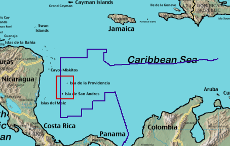
The San Andrés islands are closer to Nicaragua which is in Central America than they are to Colombia, which is in South America. Now add another dimension to that situation. The South American republic’s claim of maritime territory extends north wards absorbing San Andrés, pushing into what many considered Central American waters.
To Colombians, national territory is a particularly sensitive issue. In 1903, not surprisingly with pressure from the US Marine Corp, Colombia lost its northern state. This became the nominally independent Republic of Panama. By 1914 the Panama Canal, under US control, was built and opened. Thus the Atlantic and Pacific oceans were linked and opened to world shipping. But that’s another story.
The Nicaragua Connection
Nicaragua’s claim to sovereignty of the archipelago rested on the disputed validity of an agreement signed in 1928. With the Euerra-Barcenas Border Treaty Nicaragua accepted Colombia’s claim to the islands. This was ratified again in 1933. However, since the Sandinista Popular Revolution of 1979 this agreement has been called into question and repudiated. This is a view that has found favour with Liberals and Conservatives in Nicaragua, even after the revolutionary Sandinista government lost the 1990 election and spent 16 years in opposition.
The reason the treaty has been considered invalid by so many Nicaraguans is that it was signed when Nicaragua was occupied by US marines. At that time the ruling classes in Nicaragua, as represented by their two political parties, the Conservatives and Liberals, were in civil dispute.
The Conservatives could be said to represent ‘old money’. That is; traditional, land owning classes with an inward look on the national economy, strong on the Catholic Church and maintenance of the social order as it was and as far as they were concerned, ever would be. Historically their base has been located on the Pacific side of the country, around Grenada in the south of the country.
The Liberals were the ‘new money’. Their home turf was around the university city of León, also on the Pacific side of the country but much further north. They had an economic perspective that was much more export inclined. Never far removed from the hierarchy of the Catholic Church, history shows that their sons and heirs formed the officer class of the emerging military establishment.
These warring factions represented instability for foreign investors, most notably US investors. From what we now know of US foreign policy it is hardly surprising that President Calvin Coolidge – remembered for his words, “The business of America is business” - sent in the US marines to facilitate a move towards a US interpretation of democracy. The logging and other companies such as Standard Fruit were facing difficult times. And Nicaragua was in Uncle Sam’s back yard after all.
Someone in Nicaragua who didn’t see the unfolding events that way was Augusto Sandino. He and his followers waged an insurgency war – before such movements were thus labeled. So, Nicaragua signed the border treaty with Colombia at a time of particularly weak national government, occupation by a foreign power and an internal war of resistance against foreign aggression.
The Colombia Connection
We haven’t been given an account of the internal discussion of the jurists at The Hague but they didn’t accept the Nicaraguan argument that the 1928 treaty was invalid. The undeniable fact that the archipelago is approximately 220 Km (136 miles) off the Nicaraguan coast while lying 775 Km (480 miles) from Colombia doesn’t seem to have entered the case.
Given the decision of the ICJ it’s clear that Nicaragua lost out on its efforts to gain sovereignty of the archipelago. If, indeed, that was ever its intention. Yet the government made great sounds of delight. Why so? It seems more understandable that the social media ether was ringing with bitter recrimination from sections of the Colombian populous.
At a second glance Nicaragua has been granted a large track of Caribbean maritime territory which it had no claim to before. So what happened?
The answer to the second question comes from the chambers of the fifteen ICJ jurists holding court back on the shores of the North Sea. The 1928 treaty appears to have given much emphasis on the 82nd meridian, or line of longitude. This line runs north-south and lies west of the archipelago. The treaty gave territories west of the line to Nicaragua while those to the east, which includes the disputed islands, belong to Colombia.
The truth of the matter is that Colombia has assumed and practiced the public administration of the archipelago for decades. The islands were run as an integral part of the Colombian state. What can and has been questioned is the quality and purpose of that administration.
The Line from The Hague
Times have changed since the border treaty was signed, which is now almost beyond living memory. Apparently, in the 21st century, jurisprudence has also changed. The ICJ now places greater emphasis on the idea of a continental shelf. That has been defined by Article 76 of the United Nations Convention on the Law of the Sea (UNCLOS). As far as the law is concerned a continental shelf is the sea bed and muddy depths that extend from a country’s coast line, usually for about 200 nautical miles, but not the deep ocean floor.
Draw a line going eastward from the Nicaraguan shore for 200 nautical miles and you go past, farther east, than the archipelago. To some that would put San Andres under the sovereignty of Nicaragua. But remember that the ICJ upheld the treaty that gave sovereignty to Colombia. The islands are now beyond dispute – at least legal dispute – part of the South American republic.
But economics goes beyond – perhaps deeper- than the law. Nicaragua has got no more land but has acquired a lot more sea. It’s not a question of, “There’s gold in them there hills.” But word has it that, “There’s fish under them there waves and maybe oil beneath them there muddy depths.” For Nicaragua, the second poorest country in the western hemisphere, that’s something to be delighted about. As the ICJ’s legal ruling is final and without appeal, despite the huffing and puffing of Colombia, that should point to political stability.
The People Nobody is Talking About
The islands which make up the archipelago cover an area of approximately 57 km² (22sq. miles), just a fraction smaller than the island of Mainland in the Orkneys. Estimates of the population vary but one source, said to be based on a 2005 census, says there are close to 60000 inhabitants, 18000 to 20000 of who are said to be Raizales.
These are the descendants of European puritans, Afro Caribbean slaves and indigenous people from Central America. Given these census figures it’s clear that the Raizales are a minority marked from the Spanish speaking Catholic majority with their strong ties to main land Colombia. The Raizales have their own Caribbean Creole with influences from English and Africa languages. A good many are able to communicate in Spanish.
Their main political expression comes through the Archipelago Movement for Ethnic Native Self Determination (AMEN S-D). A starting point for finding more about the history of the Raizal and their troubled relationship with their Colombian colonisers is www.amen-sd.org
Amen S-D claims to have a copy of a secret document of the Colombian government. This shows how Colombia has intended, since the late 1970s, to irradiate the Raizal identity and way of life, not only from the Colombian state but from San Andrés itself.
At this point it’s worth taking note of the warning President Hugo Chavez of Venezuela gave regarding the regional role Colombia was assuming, when he compared Colombia to Israel in the Middle East.
Like the Zionist state, Colombia is well equipped with the latest US military hard ware. Colombia is also operating on another low intensity, yet belligerent front. It has used religion and language to marginalise the Raizales. It has pushed them off their ancestral land and encouraged South American settlers, so reducing Raizales to a minority people shunted to the edges of the local economy. And so denies them nationhood.
How will it all End?
Soon after The Hague ruling FARC representatives at peace talks with Colombian government representatives in Havana were asked for their views on the ICJ decision. But they said they preferred not to comment at this stage.
The Caribbean costal region of Nicaragua is separated into two autonomous regional areas, called North Atlantic Autonomous Region (RAAN) and South Atlantic Autonomous Region (RAAS). In many ways both these regions show language and cultural trends more closely identified with the islands of the Caribbean.
In recent years, under the present Sandinista government, road, air and river links between RAAN and RAAS and the Pacific and central zones of Nicaragua have improved. This seems to have quelled the sporadic talk of independence for the two regions. The ICJ ruling on San Andrés is unlikely to make any great change in that situation.
In the year 2000 roughly 10% of the Caribbean Sea, the part occupied by the San Andrés Archipelago, was designated the Seaflower Biosphere Reserve by the United Nations Scientific Educational and Cultural Organization (UNSCO). The area’s coral reef, dry tropical forests, unique terrestrial and marine flora and fauna gained international recognition.
Any off shore petroleum exploration and production is not welcomed by AMEN S-D.
Much of the traditional way of life of many of the Raizales has its economic base in fishing. The ruling by The Hague guarantees the islands and therefore Colombia, a 12 mile territorial limit in the now Nicaraguan waters, surrounding the islands. Nicaragua’s President Daniel Ortega says he will respect the traditional fishing customs of the island people.
But the greater oceanic area surrounding the islands may offer a greater threat to the Caribbean environment. While Nicaragua doesn’t have any real fishing fleet of industrial scale on the Atlantic coast it does have trade and cooperation partners with countries possessing sizable fishing industries.
Most notable are Russia, Japan and Taiwan. Riskier than direct development, exploitation if you prefer, of the fish stocks of these seas is the threat of indirect fishing through rent. If agreement were reached on the exploitation of these fishing grounds, between liquidity strapped Nicaragua and a third party fishing nation, a question has to be asked.
Who will monitor, oversee, and hold to account the operational activities of international fishing? If self regulation in banking is anything to go by sustainable fish stocks and the accompanying biosphere diversity are under threat.
Meanwhile, land purchase, hotel and resort development for high end tourism by non San Andreans continues. So too do decreasing living standards, low paid jobs and greater Colombianisation of the Raizal people. But since it’s all on a tropical paradise, under clear blue skies, no one is supposed to complain.